FeiYu Tech FY-21AP (Flight Stabilization System)
")
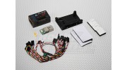


FeiYu Tech FY-21AP (Flight Stabilization System)
Awesome!
Copy and Share the Below URL
The FY21AP is a stand-alone autopilot system with FY-AFSS algorithm, GPS receiver and barometric sensing equipment. It is fully upgradable with OSD, telemetric digital communication, Data Modem and Ground Station Control (GCS).
The flexible layout makes this the most versatile autopilot system in the market, designed for beginners, UAV operators and professional RC aerial photographers.
Features
Internal use high-performance ARM processor, high stability.
10Hz GPS accurate location
Combining GPS and the barometer fix altitude accurately
complete OSD telemetry information display
Optional GCS software , monitor flight trajectory in real time
LED display for flight mode
strong anti-interference ability
Auto return to base in case of signal lose
FY-21AP features a 6DOF (Degree Of Freedom) Inertial Measurement Unit (IMU) comprising of three accelerometers, and three gyros, thus eliminating the problems of weather sensitive thermopile devices (IR horizon sensors). In addition, barometric pressure data allows precise altitude hold capability. Beyond providing stabilization for the RC Pilot, under any flight conditions, connections to our other modules allow enhancements such as:
Auto-return to launch site
Fixed-point hovering
Fixed altitude flying
Attitude change on command
With the FY21AP, the RC pilot does not need to worry about pitch, yaw, or roll fluctuations once the system is engaged. It takes away a huge part of flying stresses. Even in strong crosswinds, the FY-AFSS in this system will provide stabilization effortlessly.
OSD
Optional, See product AP117
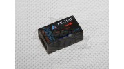
GPS Module
Launch point coordinates are logged to enable automatic failsafe return. The new FCF (Fixed Circling Function) uses GPS data for autonomous flight or defined circular navigation at predefined target points. Flexible Waypoint Input — Controlled flight with mouse. Through ground station software and electronic map, you can define flight path to any point on the map and change the flight altitude.
Data Radio Link
Additional data can be interfaced to your PC via the Data Radio Link Module upgrade:
Longitude
Latitude
Positioning condition
Working mode
Servo angles
Ground Station Software (GCS)
With the Ground Station Remote Adapter, you can monitor and control the flight on your PC. Full duplex operation is possible. If desired, our system can replace your RC receiver, in order to control all servos.